Kinder Downfall 2008 - Route Change
(also to be used in 2009)
Organiser's instructions
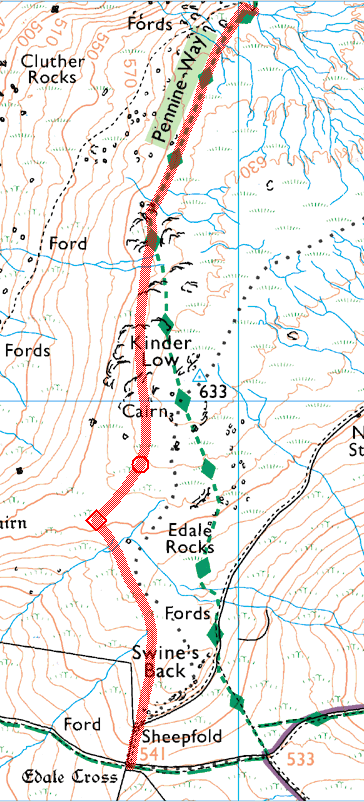
This years Downfall Race (from Red Brook to Edale Cross) will be routed along the edge path and onto the Yorkstone flags which go to the west (Hayfield side) of Swine's Back thru' to Edale Cross. On race day, there will be a marshal at the point where the flags start close to the large cairn, near to Kinder Low Trig Point. This should ensure (as far as we can!) that runners will not stray into the plateau nor onto the sensitive areas of peat moorland, which are in the process of being replanted & regenerated.
As this is also the fastest/optimum route from Red Brook to Edale Cross runners should choose to keep to it........ (excepting perhaps the most navigationally challenged!)
The race instructions will make this very clear on the day and there will be maps on display showing this requirement.
My notes & map (offered with no guarantee!)
From Red Brook (very top of the map) stay on the main path until you reach the small climb up onto the Kinder Low plateau. Here you diverge from the main path (Pennine Way). On the plateau keep to the right of the plateau peat hags passing the trig point around 150m to your left.
Keep heading south until you approach a large cairn where you bear slightly right to pick up the start of a stone-flagged path (circle symbol on map, marshal on the day). Continue on the path, bearing left where it forks (diamond symbol on map). Please stay on the path - exposed peat in that area was replanted recently (and it's faster!). Follow the path as it takes you towards Swine's Back and the flags give way to a peaty path which takes you round the west side of Swine's Back and an obvious descending path down to Edale Cross (follow wall on your right).